


Republic 2 Voting District, Ferry County, Washington
About
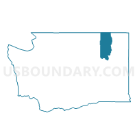
Outline

Summary
| Unique Area Identifier | 684170 |
| Name | Republic 2 Voting District |
| County | Ferry County |
| State | Washington |
| Area (square miles) | 0.43 |
| Land Area (square miles) | 0.43 |
| Water Area (square miles) | 0.00 |
| % of Land Area | 100.00 |
| % of Water Area | 0.00 |
| Latitude of the Internal Point | 48.65311950 |
| Longtitude of the Internal Point | -118.72848090 |
Maps


Graphs
Select a template below for downloading or customizing gragh for Republic 2 Voting District, Ferry County, Washington


Neighbors
Neighoring Voting District (by Name) Neighboring Voting District on the Map
- Pine Grove Voting District, Ferry County, WA
- Republic 1 Voting District, Ferry County, WA
- Republic 3 Voting District, Ferry County, WA
- Storm King Voting District, Ferry County, WA